


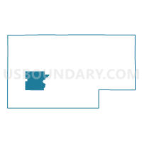
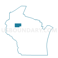
STUBBS - T 1 Voting District, Rusk County, Wisconsin
About
Outline

Summary
| Unique Area Identifier | 696740 |
| Name | STUBBS - T 1 Voting District |
| County | Rusk County |
| State | Wisconsin |
| Area (square miles) | 36.62 |
| Land Area (square miles) | 35.89 |
| Water Area (square miles) | 0.73 |
| % of Land Area | 98.00 |
| % of Water Area | 2.00 |
| Latitude of the Internal Point | 45.43251610 |
| Longtitude of the Internal Point | -91.34179730 |
Maps

Graphs
Select a template below for downloading or customizing gragh for STUBBS - T 1 Voting District, Rusk County, Wisconsin


Neighbors
Neighoring Voting District (by Name) Neighboring Voting District on the Map
- ATLANTA - T 1 Voting District, Rusk County, WI
- BIG BEND - T 1 Voting District, Rusk County, WI
- Bruce - V 1 Voting District, Rusk County, WI
- RUSK - T 1 Voting District, Rusk County, WI
- STRICKLAND - T 1 Voting District, Rusk County, WI
- THORNAPPLE - T 1 Voting District, Rusk County, WI
- WASHINGTON - T 1 Voting District, Rusk County, WI
- Weyerhaeuser - V 1 Voting District, Rusk County, WI
- WILKINSON - T 1 Voting District, Rusk County, WI
Top 10 Neighboring County Subdivision (by Population) Neighboring County Subdivision on the Map
- Bruce village, Rusk County, WI (779)
- Thornapple town, Rusk County, WI (774)
- Atlanta town, Rusk County, WI (592)
- Stubbs town, Rusk County, WI (579)
- Rusk town, Rusk County, WI (525)
- Big Bend town, Rusk County, WI (358)
- Washington town, Rusk County, WI (339)
- Strickland town, Rusk County, WI (280)
- Weyerhaeuser village, Rusk County, WI (238)
- Wilkinson town, Rusk County, WI (40)